Monday, November 16, 2015

Resources and other Information on Antarctica

                                                  Resources and other Information on Antarctica
                                             This blog will not be of much information. It will strictly
                         include a few facts, pictures, picture, more pictures, a video, and other entertaining
resources that will help you gather your thoughts about Antarctica. Without further ado...

Animals in the Antarctic:


Antarctica's Plants:

Antarctic Hairgrass


Antarctic Pearlwort
Antarctica's Map:


Antarctica's Flag:

Video on who owns Antarctica:


Sources of Information:
https://www.cia.gov/library/publications/the-world-factbook/geos/ay.html
https://en.wikipedia.org/wiki/Antarctica
http://www.nature.com/news/lakes-under-the-ice-antarctica-s-secret-garden-1.15729
www.coolantarctica.com/
http://www.worldatlas.com/webimage/countrys/an.htm
http://www.nasa.gov/topics/earth/features/20100108_Is_Antarctica_Melting.html
http://www.theatlantic.com/international/archive/2015/03/the-new-west-antarctica-yep-its-east-antarctica/388018/

How Antarctica affects the Earth Overall.

                                            How Antarctica affects the Core of the Earth

                                      Antarctica has a tremendous affect on the Earth's core.
                 When it was the SuperContinent Gondwana, it had broken up into chucks and some of those pieces even sunk into the ocean. Based on scientists' theory, they believe that land had formed under water volcanoes and other landforms. I am infeencing those pieces are still there and may have formed a major volcano or other natural landform that really affects the Earth's structure and may have something to do with global warming...

                                           How Antarctica affects the Earth's Global Warming
                                           Antarctica has a big hand in the Earth's global warming,
                      the continent does and has earlier, too. Many million years ago, Antarctica was
not as it is now, it was a SuperContinent that would later break up into about 5 continents. This SuperContinent was known as Gondwana. At that time the Earth was a cold planet, however, Gondwana was a very tropical place. Lush vegetation along with perfect animals existed there at that time, however, tectonic plate movement broke Gondwana into such small pieces, and one of those was Antaractica. Slowly, as Antarctica moved towards the South Pole, but Earth's global warming increased majorly because ice was always being formed and always being melted. Unexpectedly, though, Antarctica became the coldest place on the Earth, where once, it was the most Tropical. Due to this, Earth's global warming became very high, and along with rough weather, there were many other things. Such as more species of animals, more food, green vegetation, better quality of life, then  humans, and so on. It was a significant chain of events.


Tectonic Plate Movement


The tectonic plate movement of Antarctica's tectonic plates affects the Earth because they increase volcanic activity and modifies the structure of the Earth. This is due to the fact that tectonic plate movement creates rocks, volcanoes, other landforms, and much more. Tectonic plates are what form land on Earth, and if they move and they change, so many things on Earth change. For more information, visit the websites below.

Discoveryantarctica.org.uk
Coolantarctica.com
theantarctic.com
Enchantedlearning.com


Wednesday, November 4, 2015

Antarctica's Ice Caves and Mountains

                                             Antarctica's Ice Caves and Mountains
                                          To continue on about Antarctica's landforms, 
                           in this blog, I will speak about the Ice Continent's Ice Caves and
mountains. Some of Antarctica's icebergs inhabitat penguins and seals- two of the main animals in Antarctica. Ice caves in the continent have formed due to erosion, the seperation of the Supercontinent -Gondwana. When Gondwana broke up into many pieces because of the movement of tectonic plates under the earth's crust, it had broken into many pieces, and during the seperation of the Supercontinent, some of it actually sunk into the water, or the water covered it overtime due to global warming and other factors. Either way, however some of the continent was lost due to the water surrounding it. If you would look at the picture listed below, you will see the breakup of the Supercontinent.


Although you may not believe this, but the breakup of this Supercontinent occurred more than 200 million years ago. That is why not many people know about this- however, almost every scientist that studies geology knows about Gondwana. Along with the breakup of Gondwana, it created many ice caves because of the way the land broke and wind patterns. 
              To speak about the mountains in Antarctica, some of them are:
1). Mount Terror
Image result for antarctica mount terrorMount Terror is 10,597 inches tall and its first ascent was in 1959. This mountain is actually a shield volcano that has numerous cinder cones and that is where it gets it name: Mount  Terror.

2). Mount Berlin
Image result for mount berlin antarcticaThis Mountain is the 6th highest volcano in Antarctica and is 11,411 inches tall. It has 2 shield volcanoes, Merrem Peak and Berlin Crater. (Also, a shield volcano is a volcano that is usually built entirely out of fluid magma flows.)

3). Mount Siple
Image result for mount siple Mount Siple is a shield volcano in Antarctica which is active and dangerous to be around. Its highest elevation is 10,203 inches.

4). Mount Morning
Image result for mount morning antarctica Mount Morning is another good example of a shield  volcano with a highest elevation of 8,940 inches.

5). Mount Discovery
 Mount Discovery is a stratovolcano in the Ice Continent. For the News Flash, a stratovolcano is a volcano that is very tall and has the most viscous lava that cools and hardens very quickly as well as the fact that all stratovolcanoes are composed of one layer that fully subjects to ash, hardened lava, and tephra.

6).Mount Tyree
Image result for mount tyree Mount Tyree is know for the fact that it is the 2nd highest volcano in Antarctica at 15,919 inches tall, and its first ascent was in 1967.

7).  Mount Erebus
Image result for mount erebus Mount Erebus is known as the southernmost active volcano on the planet and is also the sixth highest ultra mountain on a specific island.

8). Mount Melbourne
Image result for antarctica mount melbourne Mount Melbourne is a stratovolcano located in Antarctica. This volcano's last eruption was in 1750. Its elevation is 8,963 inches tall.

9). Mount Andrus
Image result for mount andrus antarctica Mount Andrus is a shield volcano in the Ice Continent. It has an elevation of 9,770 inches. Its mountain range is Ames Range.

10). Mount Kirkpatrick
Image result for mount kirkpatrick This mountain is a "believe it or not" ice-free mountain in Antarctica. Its highest elevation is 14,845 inches.

Although that is not all of the information about Antarctica's Ice Caves and Mountains, it is short and precise as well as straight to the point and excellent for anyone who wants a ton of information without a lot to read. 


Saturday, October 17, 2015

Antarctica's Seas and Oceans

                                                              Antarctica's Seas and Oceans
                                                       In my previous blog, I only talked
                                about two major landforms of Antarctica. Since Antarctica's 
              landforms is such a vast and informative topic, the following (including this blog)
blogs will only cover Antarctica's landforms. In this blog, I will include information on seas and oceans. In my following blogs, I will talk about Antarctica's mountains, ice caves, icebergs, Antarctica known as a polar desert, and then just a blog with facts all about Antarctica's landforms for those of you that do not really like to read paragraph after paragraph. 
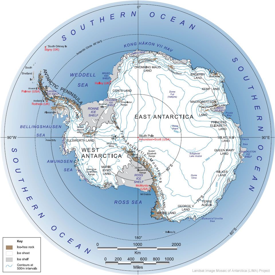
               Some of the seas around Antarctica that impact it are; Ross Sea and Weddell Sea. Some oceans around this continent are the South Pacific Ocean, Indian Ocean, and the South Atlantic Ocean. Look at the diagram below.


You can see how the oceans and seas are located around the continent and how they impact the continent. I actually think they are what makes Antarctica cold as well as other factors because water carries over radiation from the sun, as cold water evaporates, it falls as precipitation, also giving the land "temperature", and oceans also transmit their actual average temperature to the land around them because of the cold moisture they convey. For more information on this specific topic, go to the link below, which was my source of information.


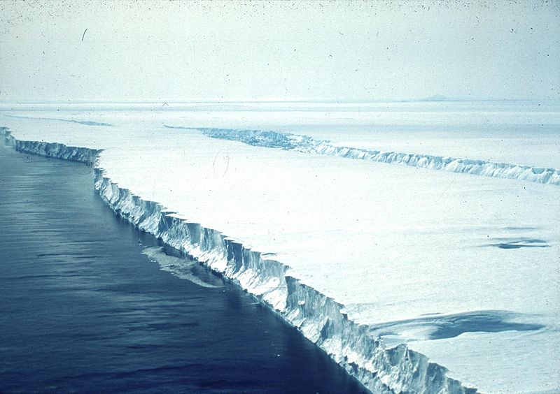
To be more narrowed down and specific, let's talk about the Ross Sea, which majorly affects Antarctica.


The Ross Sea was discovered by James Ross in 1841. In the picture above, you can see how the Ross Sea affects Antarctica and how it might be involved on other impacts on Antarctica. I could not find much information on my mentioned topic in any other source, so I am going to need to inference. Based on what I got as an answer, I think the Ross Sea is very beneficial to Antarctica. It provides so many species of krill, algae, fish, seals, more penguins, and so on. These animals are a great sight for tourists, and since Antarctica is known as such a remote continent, it will help bring a little more life to it. The Ross Sea can also be harmful, but mostly to the world as a whole. It is mostly covered with ice, and if that ice were to melt, based on my calculation, sea levels globally would increase by 30 meters, which will destroy homes, crops, sealife wildlife, affect global warming, and can carry plague and other natural disasters to the Earth. 

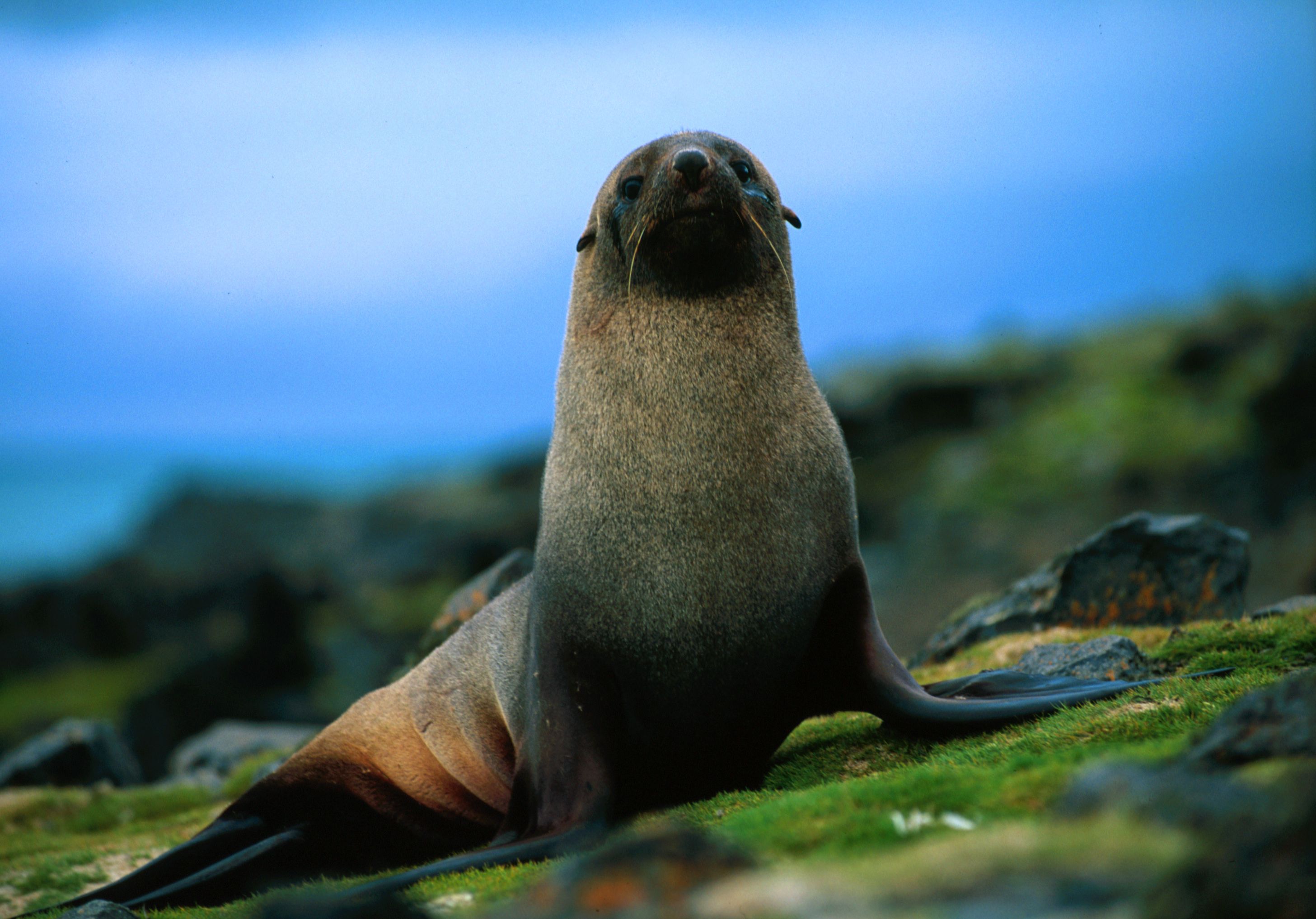
         Another sea in Antarctica is the Weddell Sea. Yes, it has a load of Weddell penguins.  

               
              The Weddell Sea was named after King George IV. Just as an interesting fact, the Weddell Sea is known as the most treacherous, most harmful, most gruesome, and it is also known as the most difficult to sail sea. The Weddell Sea is full of icebergs, and therefore is much colder than the calm, peaceful, and predictable Ross Sea. Since the Weddell Sea is cold and connected to part of Antarctica, that part of the continent is much colder. The Weddell Sea does have sea animals living inside of it, but those sea animals are used to the unpredictable and unpromising cold. It is very rare for tourists to actually go to Antarctica just to go and see the Weddell Sea. This sea is practically a death trap for humans and anyone who is not used to the harsh cold and is not one of the best sailors in the world. 

            The South Pacific Ocean, Indian Ocean, and South Atlantic Ocean all affect Antarctica, too. Look at the diagram below.


The South Pacific Ocean  is connected to the Northernmost part of Antarctica. It really mostly conveys coldness to the continent. That just about sums up its main purpose to Antarctica. The Indian Ocean, however, in my hypothesis, its main purpose is probably conveying warmth to Antarctica because it is mostly connected to Africa and Asia, two of the warmest continents on Earth. I am not quite sure of this, but it is my theory. The South Atlantic Ocean is freezing, and I am thinking it really makes Antarctica very cold. To sum it up, all the bodies around Antarctica mostly have a "cold" affect to Antarctica. 
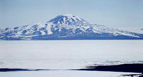


Friday, October 16, 2015

Antarctica's Landforms

                                                                     Antarctica's Landforms
                                                 Antarctica has many interesting landforms.
                                Some of these landforms are volcanoes, glaciers, seas, oceans, 
               mountains, ice caves, ice burgs, and Antarctica itself is a polar desert because it only receives 3 inches of rain or less in a whole year. I will focus on only two of these landforms. However, just for a moment, I will focus on volcanoes in the polar desert. (Antarctica)

1). Mount Berlin-Highest elevation is 3,478 meters-Latest eruption was in 8350 B.C.E.
2). Deception Island- Highest elevation is 576 meters-Latest eruption was in 1970.
3). Mount Erebus-Highest elevation is 3,794 meters-Latest eruption was in 2015.
4). Penguin Island-Highest elevation is 180 meters-Latest eruption was in 1905.
5). Mount Takahe-Highest elevation is 3,460-Latest eruption was in 5550.
If you watch the video above, you will learn about a newly discovered volcano in Antarctica.


Mount Berlin

Image result for deception island

Deception Island

Image result for mount erebus

Mount Erebus 

Image result for penguin island in antarctica

Penguin Island


Mount Takahe

There are many glaciers in Antarctica, too. A few of them are outlet glaciers, valley glaciers, cirque glaciers, tidewater glaciers, and ice streams. If you look at the pictures below and their descriptions, you will learn something new about each of these types of glaciers. 


Above is a picture of an outlet glacier. One thing that make outlet glaciers stand out from others is that they are channels of ice that come out of an ice sheet, however they are "constrained" on their sides with visual bedrock.


Valley glaciers (above) are just narrow paths of ice that are between valley walls. As seen above, the part of the picture that looks like a road made out of "snow" is the valley glacier. 


Cirque glaciers are glaciers that form on the side of mountains. They are usually in a bowl shape, almost like the one above. They usually are just land from a part of the mountain that slowly gets covered with snow.

Image result for tidewater glacier

Tidewater glaciers are simply just valley glaciers, however, they lead to the ocean.